SAMTEX Dataset

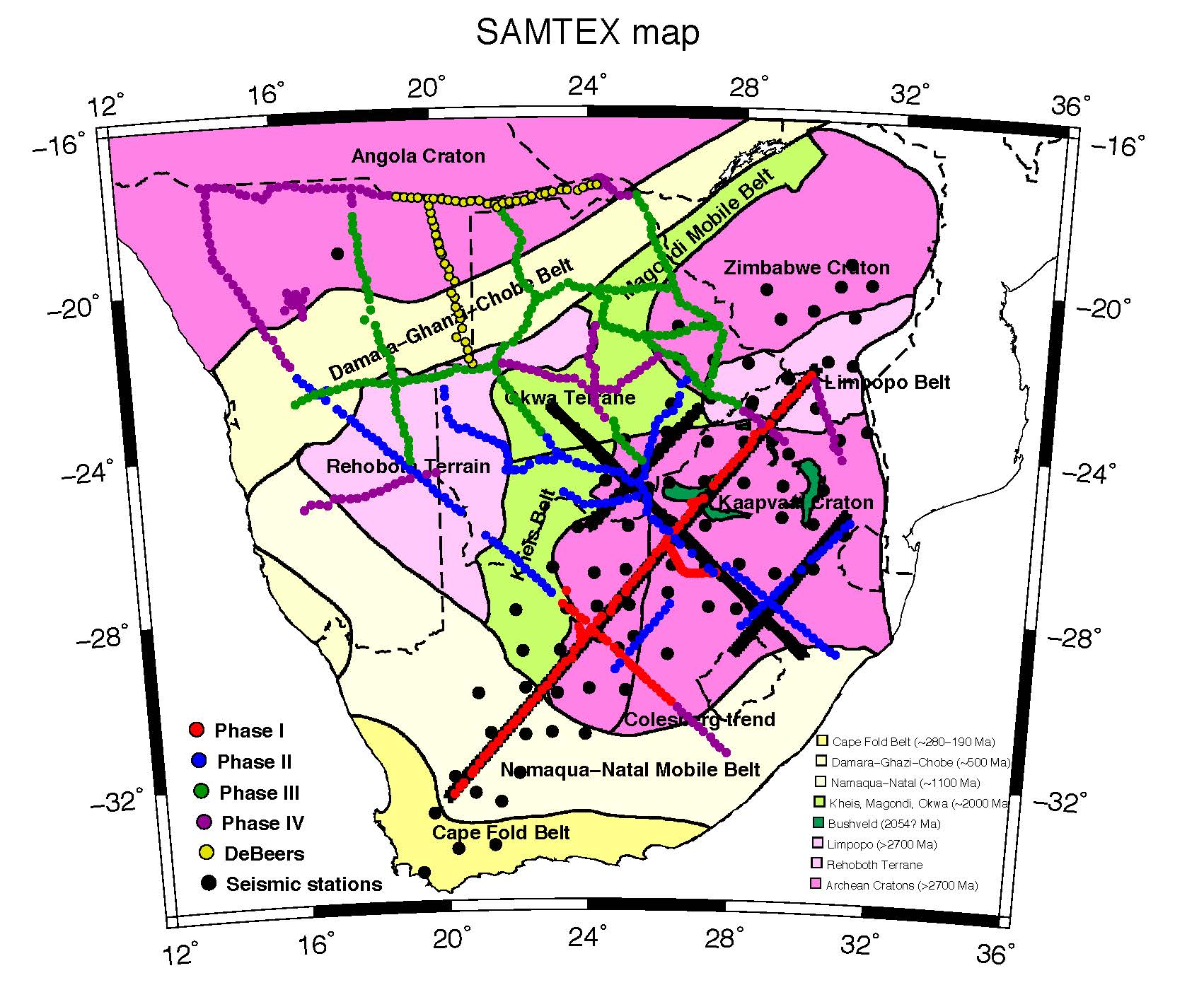
SAMTEX station map
The SAMTEX dataset comprise some 750 sites across South Africa, Namibia and Botswana, as shown in the figure above. The data were acquired over the period 2003-2008 on four field campaigns, and are BBMT at almost all sites, AMT in two concentrations (in northern Namibia and easternmost Namibia at the eastern end of the Caprivi Strip), and LMT during Phases I and II every third site.
The MT impedance tensor responses are all in GEOGRAPHIC co-ordinates.
Acknowledgements
If you download any of these time series data, or the EDI MT impedance tensor estimates, and present or publish them, you are obliged to acknowledge the SAMTEX Consortium as their source. The relevant reference is the SAMTEX overview paper by Jones et al. (2009):Jones, A.G., R.L. Evans, M.R. Muller, M.P. Hamilton, M.P. Miensopust, X. Garcia, P. Cole, T. Ngwisanyi, D. Hutchins, C.J.S Fourie, H. Jelsma, T. Aravanis, W. Pettit, S. Webb, J. Wasborg, and The SAMTEX Team, 2009.
Area selection for diamonds using magnetotellurics: Examples from southern Africa. Lithos, 112S, 83-92, doi: 10.1016/j.lithos.2009.06.011. [PDF]
and the Acknowledgements in that paper list all financial and logistical supporters.
Download data
- Download all SAMTEX EDI files (compressed zip)
Published papers using SAMTEX MT data
If you use any of these data in a publication please inform Alan Jones so that your publication can added to this list below.
-
Hamilton, M.P., A.G. Jones, R.L. Evans, S. Evans, C.J.S. Fourie,
X. Garcia, A. Mountford, J.E. Spratt, and the SAMTEX Team, 2006.
Electrical anisotropy of South African lithosphere compared with seismic anisotropy from shear-wave splitting analyses.
Physics of the Earth and Planetary Interiors, 158, 226-239, doi: 10.1016/j.pepi.2006.03.027. [PDF] -
Jones, A.G., R.L. Evans, M.R. Muller, M.P. Hamilton, M.P. Miensopust,
X. Garcia, P. Cole, T. Ngwisanyi, D. Hutchins, C.J.S Fourie, H. Jelsma, T. Aravanis, W. Pettit,
S. Webb, J. Wasborg, and The SAMTEX Team, 2009.
Area selection for diamonds using magnetotellurics: Examples from southern Africa.
Lithos, 112S, 83-92, doi: 10.1016/j.lithos.2009.06.011. [PDF]
-
Muller, M.R., A.G. Jones, R.L. Evans, H.S. Gruetter, C. Hatton, X. Garcia,
M.P. Hamilton, M.P. Miensopust, P. Cole, T. Ngwisany, D. Hutchins, C.J. Fourie,
H.A. Jelsma, S.F. Evans, T. Aravanis, W. Pettit, S.J. Webb, J. Wasborg, and The SAMTEX Team, 2009.
Lithospheric structure, evolution and diamond prospectivity of the Rehoboth Terrane and western Kaapvaal Craton, southern Africa: constraints from broadband magnetotellurics.
Lithos, 112S, 93-105, doi: 10.1016/j.lithos.2009.06.023. [PDF]
-
128: Miensopust, M., A.G. Jones, M.R. Muller, X. Garcia, and R.L. Evans, 2011.
Lithospheric structures and Precambrian terrane boundaries in northeastern Botswana revealed through magnetotelluric profiling as part of the Southern African Magnetotelluric Experiment.
Journal of Geophysical Research - Solid Earth, 116, B02401, doi: 10.1029/2010JB007740. [PDF]
-
Evans, R.L., A.G. Jones, X. Garcia, M. Muller, M. Hamilton, S. Evans, S. Fourie, J. Spratt, S. Webb,
H. Jelsma, and D. Hutchins, 2011.
The electrical lithosphere beneath the Kaapvaal Craton, Southern Africa.
Journal of Geophysical Research - Solid Earth, 116, B04105, doi: 10.1029/2010JB007883, 16pp. [PDF] -
Miensopust, M., and A.G. Jones, 2011.
Artefacts of isotropic inversion applied to magnetotelluric data from an anisotropic Earth.
Geophysical Journal International, 187, 677-689, doi: 10.1111/j.1365-246X.2011.05157.x. [PDF] -
Jones, A.G., J. Fullea, R.L. Evans, and M.R. Muller, 2012.
Calibrating laboratory-determined models of electrical conductivity of mantle minerals using geophysical and petrological observations.
Geochemistry, Geophysics, Geosystems, 13, Q06010, doi: 10.1029/2012GC004055. [PDF] -
Khoza, D., A.G. Jones, M.R. Muller, R.L. Evans, S.J. Webb, M. Miensopust, the SAMTEX team, 2013.
Tectonic model of the Limpopo belt: Constraints from magnetotelluric data.
Precambrian Research, 226, 143-156, doi: 10.1016/j.precamres.2012.11.016. [PDF] -
Jones, A.G., S. Fishwick, R.L. Evans, M.R. Muller, and J. Fullea, 2013.
Velocity-conductivity relations for cratonic lithosphere and their application: Example of Southern Africa.
Geochemistry, Geophysics, Geosystems, 14, No. 4, 806-827, doi: 10.1002/ggge.20075, ISSN: 1525-2027. [PDF] -
Khoza, D., A.G. Jones, M.R. Muller, R.L. Evans, M.P. Miensopust, and S.J. Webb, 2013.
Lithospheric structure of an Archean craton and adjacent mobile belt revealed from 2D and 3D inversion of magnetotelluric data: example from southern Congo craton in northern Namibia.
Journal of Geophysical Research - Solid Earth, 118, Issue 8, 4378-4397, doi: 10.1002/jgrb.50258. [PDF] -
Share, P.-E., A.G. Jones, M.R. Muller, D.T. Khoza, M.P. Miensopust, and S.J. Webb, 2014.
An audio-magnetotelluric investigation of the Otjiwarongo and Katima Mulilo regions, Namibia.
Geophysics, 79, B151-B171, doi: 10.1190/GEO2013-0171.1. Geophysics Case History. [PDF]